We are committed to providing the highest quality professional services and survey documents to meet all our clients needs at a competitive fee.
Utility Location
Contact us to mark the
location of underground utilities
before you dig, drill, or design your next project. We can
provide you with just utility mark out or utility mark out with
utility mapping.
RDM Surveying Consultants provides
state-of-the-art utility locating for all pre-excavation and
site planning needs as well as
ground fault locating. We at
RDM Surveying Consultants do quality work, NOT quantity. We
strive to save you time and money by giving you the most
complete information about utilities in your designated areas.
All our utility locating
surveys are performed
with the RD8000 cable and pipe locator. The RD8000, which is
manufactured by the Radiodetection Corp., is widely recognized
as the industry standard because it maintains the highest
location performance, contains multiple location modes, and is
easy to use. When necessary
Ground Penetrating Radar may
be used for locating underground utilities not found with the
RD8000.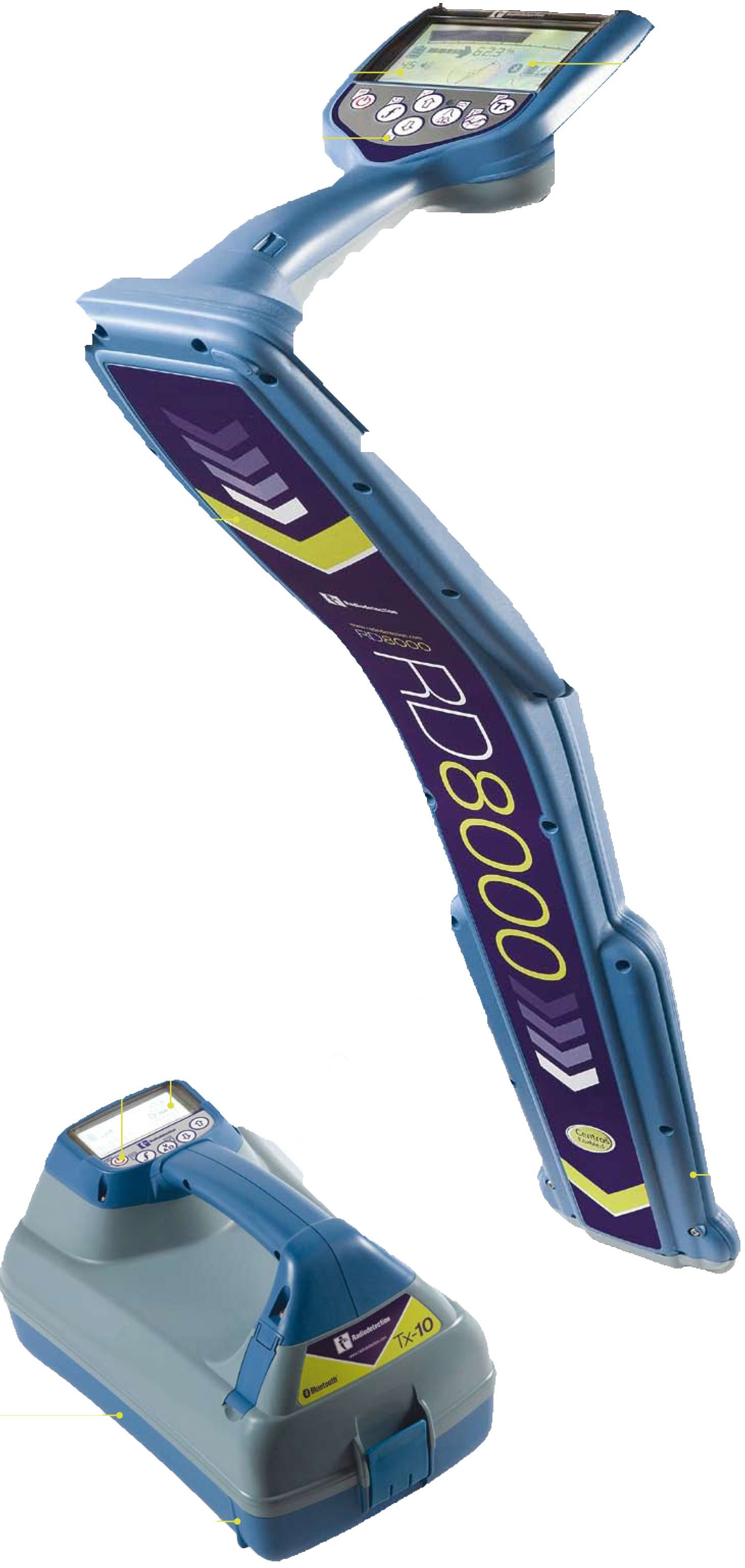
GPR is a non-invasive, non-destructive
geophysical surveying technique that is used to produce a
cross-sectional view of objects embedded within the subsurface.
Quite often, non-metallic, inaccessible, unknown, or abandoned
utilities cannot be located with traditional cable and pipe
locators. When this occurs, GPR must be used.
GPR profiles are used for evaluating the
location and depth of buried objects such as utilities (metallic
and non-metallic), burial site location, tanks, and voids along
with Geophysical and Environmental assessment.
GPR operates by transmitting pulses of
ultra high frequency radio waves into the ground through an
antenna. The transmitted energy is reflected from various buried
objects or distinct contacts between different materials. GPR
waves can reach depths of up to 100 feet in low conductivity
materials such as dry sand. Clays, shale and other high
conductivity materials, may attenuate or absorb GPR signals,
greatly decreasing the depth of penetration to 3 feet or less.
The depth that can be probed is a function of the earth’s
conductivity in the area to be searched.
Whether you are looking to
minimize the costly risks associated with excavations or need to
locate underground utilities for design purposes RDM Surveying
Consultants can provide you with
THREE
different quality levels of utility location.
The first provides the most basic level of
information. This involves
collecting data from existing utility records. Records may
include as-built drawing, distribution and service maps,
existing geographic information system databases, and
construction plans. Engineers, architects, designers, and
contractors must be very careful when using this data for any
purpose.
The second quality level involves
surveying visible subsurface utility structures such as
manholes, hand-holes, utility valves and meters, fire hydrants,
pedestals and utility markers, and then correlating the
information with existing utility records to create composite
drawings to establish potential utility routes. This method does
not address utilities for which there are no records or
utilities for which there is no visible above ground features.
Again, you must be very careful when using this data.
The third quality level involves
designating the horizontal position of subsurface utilities
through appropriate geophysical methods. There are many
different methods that can be used to identify the existence and
horizontal locations of existing underground utilities. After
the horizontal locations of the utilities are designated with
field-markings, the locations are collected through survey
methods and referenced to the project control. This information
is than inserted into the project plans. Not all utilities may
be found using surface geophysics. Of course, the best location
of underground utilities is to locate them during construction
or to dig them up and visually verify their location.
It takes
more than just well trained technicians
or high tech equipment to provide the client with an accurate
survey of underground utilities. It takes a comprehensive and
time proven process. All our utility locating surveys are
performed by following a four-step process as shown below:
1. Research
a.
The State
"One Call" center is contacted.
b.
Site maps or
as-builts are obtained from municipalities, maintenance
personal, superintendents, property owner, or contractor(s) that
laid the utilities.
c.
The before
mentioned individuals are interviewed.
2. Inspect
a.
Utility
Structures – A visual inspection of the property and building is performed
to search for utility poles, conduits, pull-boxes, site lighting
structures, manholes, catch basins, sewer cleanouts, gas vents,
and gas/water meters, valves, and caps.
b.
Anomalies
–The ground is inspected for asphalt patches, cracks, or
sinkholes.
3. Survey
& Designation
a.
Cable and
Pipe Locating
- An
active signal is applied to:
- Metallic pipes and conduits
via connection leads
- Electric, telephone and
cable lines connected via a transmitter clamp.
- Inaccessible, abandoned,
and/or unknown lines via induction.
- Detectable duct rod or
sonde are inserted into accessible manholes,
handholes, catch basins, or cleanouts.
- Metallic pipes and conduits
via connection leads
- Passive sweep is performed to
search for inaccessible, abandoned, and/or unknown
lines.
b.
Ground
Penetrating Radar (GPR) Survey
i.
GPR survey is
performed within entire survey area if necessary to search for
non-metallic, unknown, abandoned and/or inaccessible lines.
c.
Location and
depth of underground utilities are marked on the ground with
colored paint and/or flags.
4.
Report
a.
Consultation
is performed with an onsite representative to discuss results of
the survey.
b.
Written
report (with or without a utility map) is prepared for
documentation.
We at RDM Surveying Consultants believe
in always giving you the best information to help save you time,
money, and resources. Our job does not end when we drive off
your site. Utility Mapping helps to leave you with something
tangible from our work. After we have taken careful
consideration in marking all of your underground utilities, the
locations are collected through survey methods and referenced to
the project control enabling us to provide you with an as-built
plan, or both a hard copy and a computer CAD file. We do this to
provide you with a great reference guide and to provide you with
a much more defined starting point for any future projects you
may have. Should you need our services again, we would be able
to verify lines more quickly for you.